I'm slowly improving the process of generating the KML files from Census boundary files. One of the challenges with wanting to show data for the entire country is that the boundary files are, at every level, broken out by state. There is no roll up for the entire country, even for the larger geographic areas. With the help of FlashGot, I've written a Ruby script that can take a directory full of ASCII boundary files, reading both the polygons & the metadata components, and create KML outputs. I am still generating each state as a separate KML file for viewing reasons, but I also generate a master KML file that links to each of the individual ones.
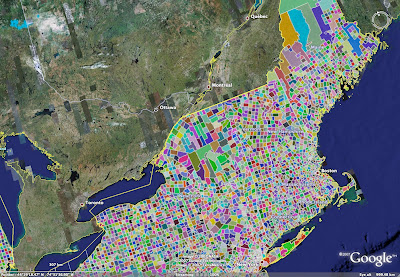
The following picture shows a map of all County Subdivisions from the 2000 Census. The colors are random.
This is a zoom of New England, with borders around each subdivision:
Thursday, March 8, 2007
County Subdivsions
Posted by
aidan
at
4:18 PM
![]()
Subscribe to:
Post Comments (Atom)
1 comment:
Hi, You are doing great work. Is this master file available somewhere on public server.
I show census files but they are multiple and not in standard format that google can understand.
I would really appreciate if you can share or let me know if this master file is available somewhere.
Post a Comment